An'nong River Bikeway
17KRunning along the banks of the An'nong River, it pairs well with the old railway line, with pleasant farmland and bald-cypress scenery on either side.
Forest Railway· Stations Along the Line
Ten Stations · A Century of the Luodong Forest Railway
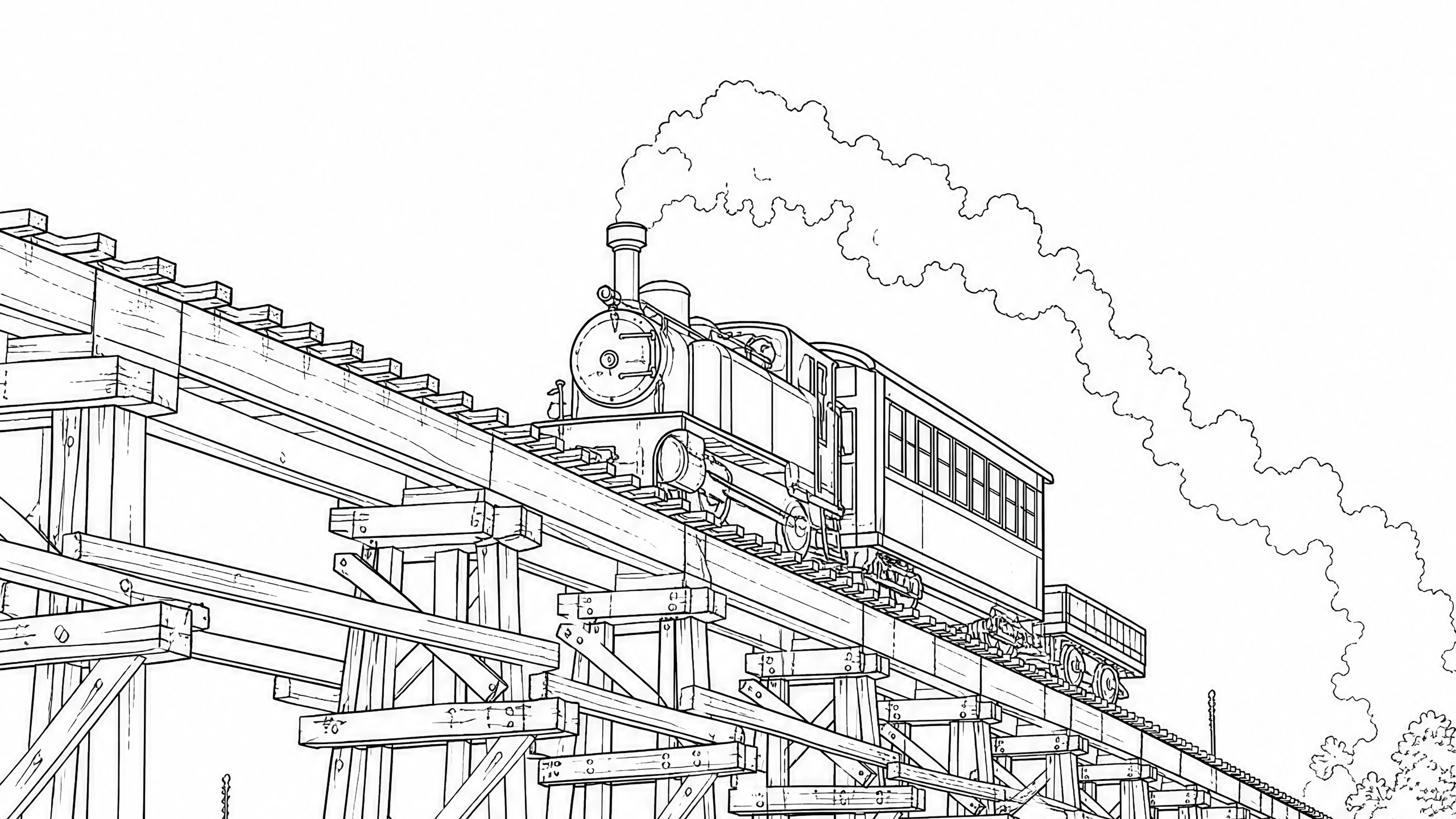
The Luodong Forest Railway is a century-old imprint of modern forestry and everyday life in Yilan. Because of the terrain, Taipingshan's timber-hauling railway was split into a 'mountain line' and a 'lowland line' — and the lowland line, running straight across the Lanyang plain, is the Luodong Forest Railway.
Its track gauge is only 762 millimetres; the carriages are narrow and its power roughly half that of an ordinary train — which is why the people of Yilan fondly call it the 'Five-Tenths Train.' The full line opened in 1924, carrying Taipingshan's hinoki cypress down the mountain station by station, and pushing Luodong to become the commercial and industrial heart of the Lanyang plain.
Later, as roads spread and storms washed away bridges and track bed, the trains stopped running in August 1979. The old line was handed over piece by piece to the Sanxing Township Office and opened as local roads — and today you can still drive or cycle it, stopping at each station in turn, and walk once more through half a century of the forest railway's heyday.
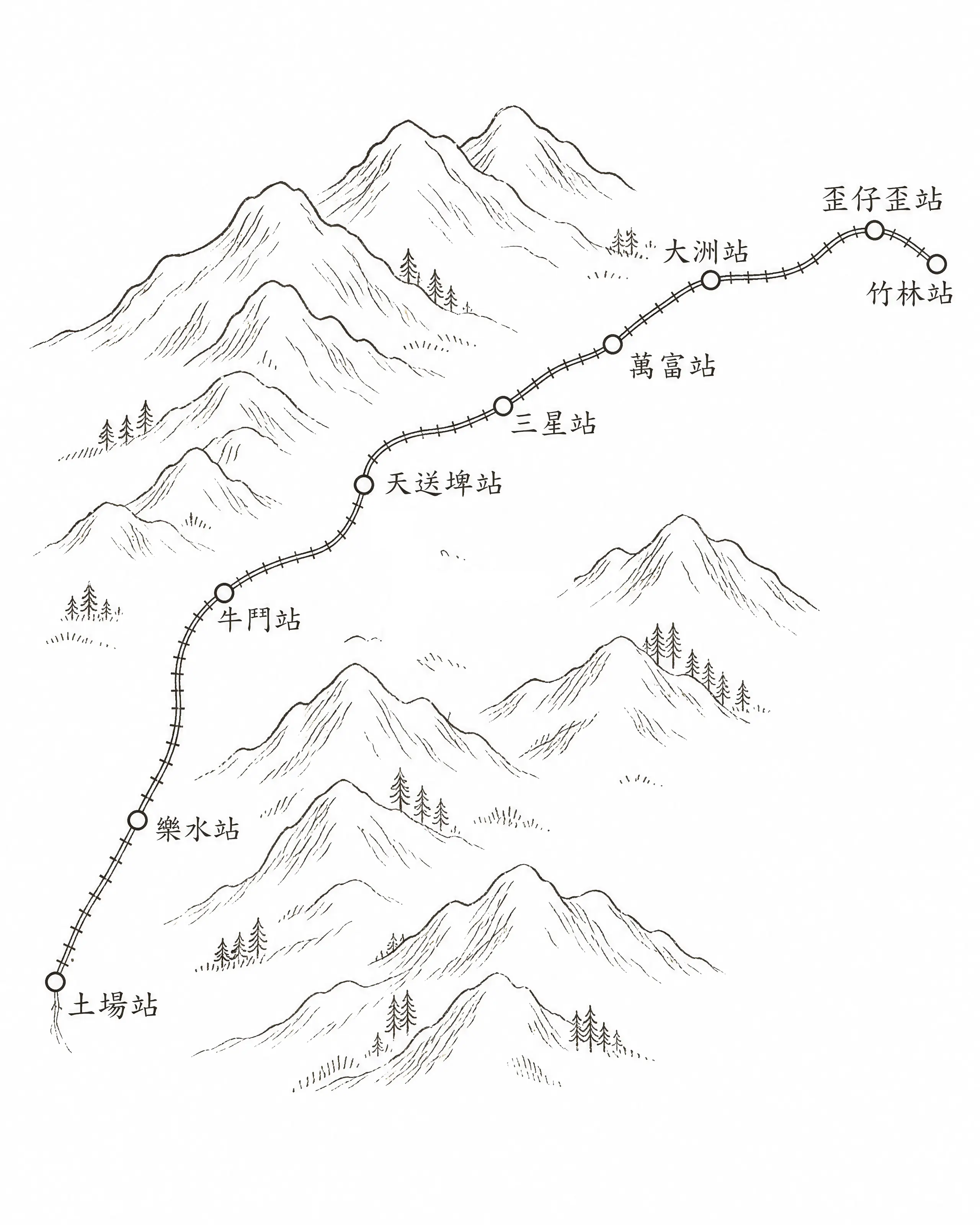
Stations Along the Line
From Zhulin to Tuchang, station by station along the lowland line.
Section One · Zhulin–Waiziwai
1924 · the Donation Line
The 'donation line' (kifu, Japanese for a charitable gift), championed by Chen Chunjing, then head of Luodong Street, was completed in 1924 and set off decades of prosperity for Luodong.
▲ Within Luodong Forestry Culture Park, Zhongzheng North Road, Luodong, Yilan County
The starting terminus of the Luodong Forest Railway is tucked inside today's Luodong Forestry Culture Park. The tracks, a locomotive, the washing platform, the log pond, the log-unloading dock, even the old staff dormitories are all preserved intact — a forest-railway site you can walk right into.
▲ Beside the Waiziwai Bridge, Ren'ai Road Section 3, Luodong, Yilan County
In the early years, the dividing point between hauling timber and hauling sugarcane. After 1945 the station was torn down and the site turned to farmland, while the old railway became Ren'ai Road; the Waiziwai Bridge over the Luodong River was swapped from a raised hinoki-cypress trestle for one of concrete. In the Kavalan language, 'Waiziwai' means 'rattan.' By legend, the people of the Waiziwai (Kavalan) community put to sea in boats all woven from rattan. The place was also known as 'Fanshetou,' an old name meaning an Indigenous settlement; as Han settlers moved in to cultivate the land, most of the community moved away, and so the place came to be called 'Waiziwai.'
Section Two · Waiziwai–Tiansongpi
Leased from the Tainan Sugar railway
This section was leased from the railway of the Tainan Sugar Company, so six trains a day carried sugarcane, threading slowly through the cane fields.
▲ No. 78, Dazhou Road, Dazhou Village, Sanxing Township, Yilan County
Under contract with the sugar mill, the Dazhou area once grew the densest sugarcane of all. The whistle sounding across the cane fields as the train rolled slowly by is a memory shared by the older generation of Dazhou.
▲ Beside County Route 196, Wanfu Village, Sanxing Township, Yilan County
Renamed 'Wanfu' Station after the war, its building rebuilt several times over, it still keeps a track-gang house and staff dormitories nearby. The place name 'Erwanwu' — literally 'twenty-five thousand' — is said to come from the roughly twenty-five thousand catties of sugarcane that one jiǎ of farmland could yield in those days.
▲ Within Sanxing Park, Yixing Road, Sanxing Township, Yilan County
Once the busiest station in Sanxing Township, where people from the nearby villages would take the train in to buy their daily goods. The building has been demolished; its site is now Sanxing Park and a seniors' activity centre, keeping a few lengths of track as a memento, while the original alignment has been widened into Yi-44 Road.
▲ Between No. 27 and No. 41, Heng Lane, Tianfu Village, Sanxing Township, Yilan County
The best-preserved station on the whole line: the track bed, the track-gang house, the water tower where steam engines took on water, and the locomotive turntable all remain, and together with the surrounding village buildings they make Tiansongpi a place rich in both history and everyday life.
Section Three · Tiansongpi–Tuchang
1921 · Taiwan Electric Industries
In 1921, the Taiwan Electric Industries Company funded this section of railway to develop hydroelectric power.
▲ Beside the Qingshuihu bus stop, Taiya 1st Road (Provincial Highway 7C), Yuanshan Village, Sanxing Township, Yilan County
Later renamed 'Qingshuihu' Station; its residents were mostly power-plant workers and Taipingshan loggers. When the logging ended and the plant was automated, people moved away in great numbers and the station fell into disuse. The nearby Yuanshan unit of the Lanyang Power Plant is a run-of-river station drawing on the Lanyang River, now operated by remote control from the Tianpi control room.
▲ In front of the old camphor tree, Niudou Lane off Taiya 1st Road, Yuanshan Village, Sanxing Township, Yilan County
Set in the narrow gap where the Xueshan and Central mountain ranges meet, the slopes on either side lock together like two bulls' horns — hence the name 'Niudou,' bulls locking horns. A mountain-entry checkpoint once stood here, and because the trains lingered a while, peddlers with bamboo baskets would gather to hawk their wares.
▲ No. 230, Leshui Road, Leshui Village, Datong Township, Yilan County — before the Leshui Bridge on township road Yi-51
In Datong Township, originally Zhuoshui Village, renamed 'Leshui' after the war (and for a time called 'Malun'). Its convenient location once made it the most prosperous community here, with a Shinto shrine, a clinic, and a school, and loggers gathered from all over, giving it a remarkably mixed population. After the forest railway closed and the administrative centre moved away, it declined into what people call 'the forgotten village' — a settlement once divided into three parts: Chinau, Varloon (Malun), and Dorei.
▲ Near No. 17, Tuchang Lane, Tuchang Village, Datong Township, Yilan County
'Tuchang' means a place where timber gathers — in the forestry vocabulary of the Japanese colonial era, any point where logs were collected and unloaded was a tuchang, and this one is the very start of the forest railway's lowland line. It was the transfer point between the mountain line and the lowland line, and the terminus at the far end of the Luodong Forest Railway: the hinoki cypress floated down from Taipingshan changed here onto the forest railway and set off, hugging mountain and river, toward Zhulin. On the site today stand a rebuilt Tuchang Station and a forest-railway history exhibit, right beside the entrance to the Taipingshan National Forest Recreation Area.
Three landmarks from the story, rebuilt as 3D models you can spin with your own hands.
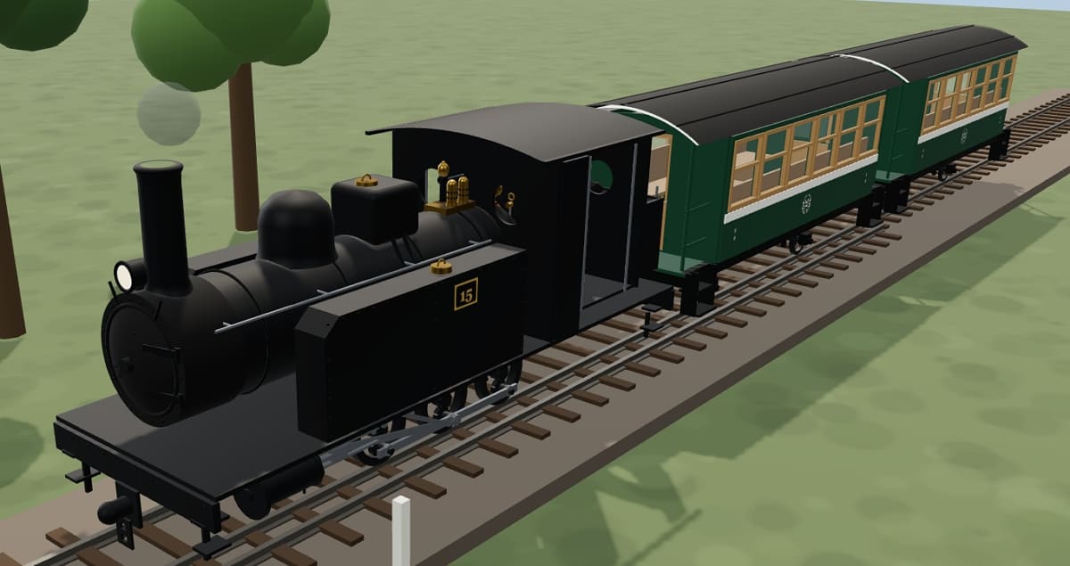
Steam locomotive No. 15 at Zhulin Station, wooden carriages coupled behind.
'Route Map of the Luodong Forest Railway Stations' — the ten stations along the line, the recommended present-day route, the old railway alignment, and nearby services at a glance. Tap the image for full resolution.
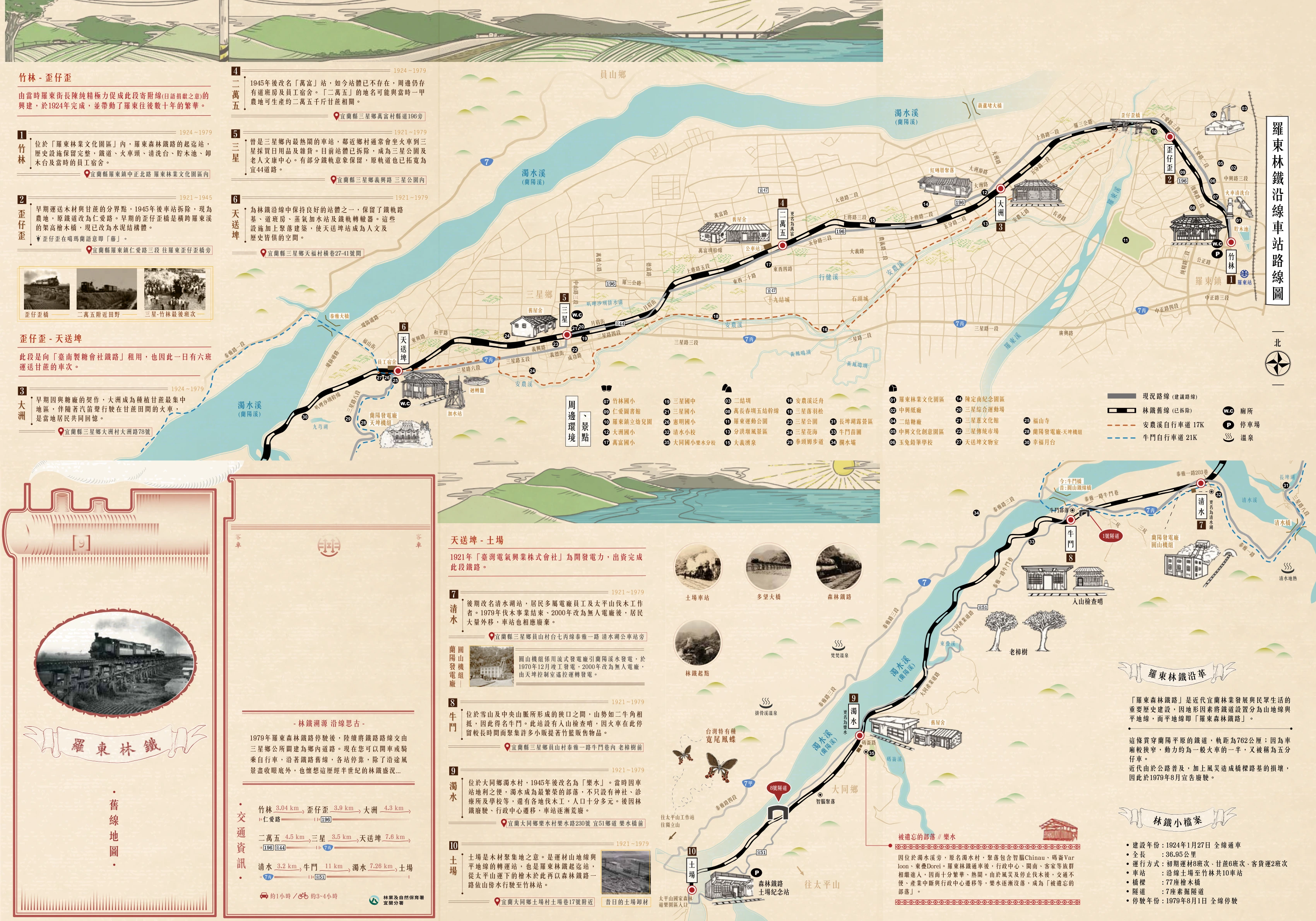
A suggested route, stopping at each station along the old line.
| 區間 | 距離 | 沿線道路 |
|---|---|---|
| Zhulin → Waiziwai | 3.04 km | Ren'ai Road |
| Waiziwai → Dazhou | 3.9 km | County Route 196 |
| Dazhou → Erwanwu | 4.3 km | — |
| Erwanwu → Sanxing | 4.5 km | County Route 196, Yi-44 |
| Sanxing → Tiansongpi | 3.5 km | Provincial Highway 7C |
| Tiansongpi → Qingshui | 7.6 km | — |
| Qingshui → Niudou | 3.2 km | Provincial Highway 7C |
| Niudou → Zhuoshui | 11 km | Yi-51 |
| Zhuoshui → Tuchang | 7.26 km | — |
The whole route takes about an hour by car, or about 3–4 hours by bicycle.
Running along the banks of the An'nong River, it pairs well with the old railway line, with pleasant farmland and bald-cypress scenery on either side.
Following the Lanyang River upstream toward Niudou, it runs parallel to the old line, stringing together the valleys and river views along the way.
Compiled and adapted from the travel map 'Route Map of the Luodong Forest Railway Stations' (issued by the Yilan Branch of the Forestry and Nature Conservation Agency), with reference to the Wikipedia entries for the 'Luodong Forest Railway' and its individual stations, railway-history blogs, and other public sources. Opening hours, road conditions, and ticketing are subject to the official announcements of the Yilan Branch of the Forestry and Nature Conservation Agency.
Tuchang, the end of this lowland line, is exactly where the Welcoming of Mazu at Taipingshan begins its climb into the mountains.